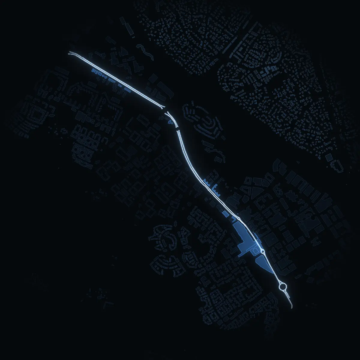
The street at night: Hanstavägen drawn in white, its buildings lit in the colour of their area’s income
Mean net income of the area
SEK 233kSEK 516kSEK 1,143k+
Every building in the colour of its DeSO area’s mean net income in 2024 (SCB) – never a price, never a person. The street is drawn in white, its own buildings lit.

Sweden › Stockholm › Stockholm stad › Kista · street

Living on Hanstavägen.

21 buildings stand along its 3,450 m in Kista, Stockholm stad. The 3 DeSO areas it runs through have a mean net income of SEK 295k, and 47% of their dwellings are bostadsrätter. Kista (tunnelbana) is a 4-minute walk.

74VERA PI Scoreno. 1 of 77 in Kista · no. 1,140 of 4,346 in the city

The street as OpenStreetMap maps it, its area as SCB counts it. VERA PI shows no street price in Sweden – why, below.

3,450 mlong
21buildings along it
SEK 295karea net income, 2024
47%bostadsrätt in its areas
4 minwalk to Kista
14school units within 500 m

VERA PI Score

74of 100

Better placed than 74% of Stockholm's 4,346 streets – no. 1,140 in the city and no. 1 of 77 in Kista.

Stockholm's 100 best streets

What it is made of

Getting around35% of the score78
4 min walk to Kista (metro)
Parks & green25% of the score75
Akalla Stadspark 2.3 ha, 560 m · Saimaparken 1.6 ha, 340 m
Area income25% of the score8
SEK 295k mean net income, 2024 – the latest SCB publishes per area
Schools15% of the score99
14 within 500 m · nearest Norrbyskolan, 120 m

Coming: Heritage – Stadsmuseet's inventories · Restaurants & culture · Safety – Brå · Air · Flood

How the score is counted

Each part is a rank among all of Stockholms stad's streets; the parts are weighted and the total ranked again – the same measure for every street, so any two can be compared and shared. It is VERA PI's own ranking, not a price and not a valuation.

Sources: OpenStreetMap (ODbL), SL's stops, Skolverket, SCB (mean net income 2024 per DeSO) · VERA PI Score v1, calculated 21 Oct 2026, 14:52.

Ask VERA · VERA PI

Ask VERA about Hanstavägen

Three questions to VERA PI's assistant – free for members. The answers are built on VERA PI's own data for the place, with source and date.

General information – not financial or legal advice. Your question is not stored. About Ask VERA

The street

Hanstavägen, as it stands.

Hanstavägen is a through road of about 3,450 m in Kista, Stockholm stad (stadsdelsområde Järva). OpenStreetMap draws 21 buildings within 25 m of its line, typically 3 floors high where the floors are mapped (6 of them).

Length3,450 mIts parts counted once – a boulevard’s side lanes are not added twice.
Buildings along it21Outlines within 25 m of its line (OSM).
Homes among them4Tagged as flats or houses in OSM.
Its areas3Kista · Akalla

What the buildings are

OpenStreetMap’s own tags – most Swedish buildings carry no use, so «not tagged» is common and says nothing about the building.

Homes (flats, houses)19%
Other uses33%
Not tagged48%

For sale on this street – asking prices

For sale on Hanstavägen.

0 homes on Hanstavägen for sale on the agencies’ own websites, read 21 Oct 2026. These are asking prices, not sale prices – VERA PI still shows no sale price for a street.

0 homes for sale

    Sold or off the market · 1
    • Off the marketHanstavägen 92

      Bostadsrätt · 5 rooms · 93.5 m² · floor 6 av 7, hiss finns · built 2012

      HusmanHagberg · The agency’s advert ↗ · property Skagafjord 4 · seen 20 Oct 2026 – 20 Oct 2026, gone 21 Oct 2026

      Asking price by day · 2
      20 Oct 2026SEK 3,495,000For sale
      21 Oct 2026–Off the market
      SEK 3,495,000asking · SEK 37,380 per m²fee SEK 6,250 a month

    Sorting and filters are worked out in your browser from the night's 1 listings, read 21 Oct 2026 – asking prices, never sale prices. Filtered addresses are not indexed. VERA PI

    Asking prices as the agencies publish them on their own websites, read by VERA PI every night (robots.txt and each site’s terms obeyed) – not sale prices, and not every agency: Hemnet’s and Booli’s terms forbid copying, and VERA PI does not use them; sites that forbid automated reading are not read. A home sold by two agencies can appear twice. The agency’s name only – never an agent’s or a seller’s.

    All of Stockholm stad for sale

    Close by

    The nearest care and everyday places from Hanstavägen, nearest first, with the way there in Google Maps or Apple Maps. Emergency care is shown however far it is; everything else within 2 km.

    Care

    In an emergency, call 112Medical advice day and night: 1177

    Everyday

    Distance in a straight line from the nearest point of the street; the walk is estimated at 1.3 times that, at 80 metres a minute. Source: © OpenStreetMap contributors (ODbL), emergency departments, urgent care and health centres from 1177 (Region Stockholm), police stations from Polisen, read 21 October 2026.

    Along the street

    The named places on Hanstavägen as OpenStreetMap maps them – shops, food and drink, culture, hotels and more – each with the way there.

    Food & drink14

    Show 9 more

    Shops & design30

    The first 24 of 30, in address order

    Show 19 more

    Parks & nature3

    Good to know1

    A place is on the street when its address is on it, or – without an address – when it lies within 30 metres of the street and the street is the nearest; parks on every street they border. Shops inside a shopping centre are counted on the centre. Source: © OpenStreetMap contributors (ODbL), data until 18 October 2026.

    The area around it

    Who lives around it.

    The street runs through 3 of SCB’s DeSO areas – Kista, Akalla. Together they have 7,676 people (2025) with a mean net income of SEK 295k (2024), −37.0% against Stockholm stad as a whole. These are the areas’ figures, not the street’s: SCB counts people by area, never by street.

    How the dwellings are held

    Dwellings in the DeSO areas the street runs through, 4,191 in all.

    Bostadsrätt47%
    Rented (hyresrätt)53%
    Owned (äganderätt)1%

    Against Stockholm stad

    • Mean net incomeSEK 295k here · SEK 468k in Stockholm stad
    • Bostadsrätt47% here · 49% in Stockholm stad
    • Rented53% here · 43% in Stockholm stad

    People 2025, net income 2024 and dwellings by tenure by DeSO area: Source: Statistics Sweden, CC BY 4.0 – an area counts where at least a tenth of the street runs through it.

    The 2026 election

    The general election of 13 September 2026, final result, in the 8 voting districts Hanstavägen runs through, the largest share of the street first. The figures are each whole district's, not just the street's.

    The districtStockholm stad

    Kista 19 Kista Ö27% of the street · turnout 46.6%
    Party2026vs 2022
    Moderates9.5%–
    Centre Party3.6%–
    Liberals2.6%–
    Christian Democrats2.9%–
    Social Democrats32.9%–
    Left Party33.4%–
    Green Party5.5%–
    Sweden Democrats6.7%–
    Other parties2.9%–

    The district's boundaries have changed since 2022, so Valmyndigheten does not compare it with 2022.

    Kista 2 Akalla Ö25% of the street · turnout 56.3%
    Party2026vs 2022
    Moderates6.9%−2.4
    Centre Party2.9%+0.6
    Liberals1.1%+0.6
    Christian Democrats2.3%−0.2
    Social Democrats47.2%+9.2
    Left Party27.3%−4.7
    Green Party3.7%+1.6
    Sweden Democrats6.9%+0.7
    Other parties1.8%−5.4
    Kista 16 Kista Gård17% of the street · turnout 61.1% · along its boundary
    Party2026vs 2022
    Moderates14.3%–
    Centre Party3.4%–
    Liberals1.7%–
    Christian Democrats2.7%–
    Social Democrats36.3%–
    Left Party28.4%–
    Green Party4.7%–
    Sweden Democrats7.3%–
    Other parties1.2%–

    The district's boundaries have changed since 2022, so Valmyndigheten does not compare it with 2022.

    Kista 14 Kista V8% of the street · turnout 61.9%
    Party2026vs 2022
    Moderates14.1%–
    Centre Party3.4%–
    Liberals2.7%–
    Christian Democrats3.1%–
    Social Democrats37.4%–
    Left Party26.0%–
    Green Party5.2%–
    Sweden Democrats6.5%–
    Other parties1.6%–

    The district's boundaries have changed since 2022, so Valmyndigheten does not compare it with 2022.

    Kista 6 Lofotenparken8% of the street · turnout 63.9% · along its boundary
    Party2026vs 2022
    Moderates6.9%−5.5
    Centre Party1.5%−1.4
    Liberals1.2%−0.6
    Christian Democrats2.3%±0.0
    Social Democrats45.9%+6.8
    Left Party30.1%+5.4
    Green Party3.4%+1.2
    Sweden Democrats7.2%−0.9
    Other parties1.4%−5.1
    3 more districts
    Kista 10 Nordkapsgatan6% of the street · turnout 60.8% · along its boundary
    Party2026vs 2022
    Moderates5.5%−3.7
    Centre Party1.5%−2.7
    Liberals0.3%−0.3
    Christian Democrats0.8%−0.7
    Social Democrats38.9%+4.4
    Left Party42.4%+15.6
    Green Party3.7%−0.5
    Sweden Democrats6.4%−3.2
    Other parties0.3%−9.1
    Kista 8 Nidarosgatan5% of the street · turnout 60.5% · along its boundary
    Party2026vs 2022
    Moderates4.6%−1.5
    Centre Party1.4%−3.0
    Liberals0.9%−0.6
    Christian Democrats0.9%+0.1
    Social Democrats40.4%+6.0
    Left Party44.5%+14.8
    Green Party2.7%+0.6
    Sweden Democrats3.4%−3.6
    Other parties1.4%−12.5
    Kista 3 Akalla N4% of the street · turnout 61.9%
    Party2026vs 2022
    Moderates11.4%±0.0
    Centre Party2.7%−1.2
    Liberals1.8%+0.6
    Christian Democrats2.9%−0.3
    Social Democrats47.7%+10.1
    Left Party21.7%−1.2
    Green Party3.2%−1.7
    Sweden Democrats6.8%−3.3
    Other parties1.7%−3.2

    Stockholm stad, the county and Sweden

    PartyStockholm stadCountySweden
    Moderates19.1%21.8%19.9%
    Centre Party9.8%8.6%7.0%
    Liberals7.1%6.8%5.3%
    Christian Democrats3.9%4.9%6.2%
    Social Democrats26.3%26.0%28.0%
    Left Party13.0%10.2%8.4%
    Green Party11.1%8.0%6.1%
    Sweden Democrats8.4%12.1%17.5%
    Other parties1.2%1.4%1.6%
    Turnout85.8%84.7%84.9%

    Share of valid votes in each district. The tick on each bar is the whole kommun's result (Stockholm stad). Change since 2022 in percentage points, where Valmyndigheten says the district can be compared. Early votes that arrived late are counted in the kommun's collection district and are in no district's shares. The election is not part of the VERA PI Score. Source: Valmyndigheten, final result, published 7 October 2026. Valmyndigheten's data

    Getting around

    Stations, schools and parks.

    The nearest stop is Kista – 330 m on foot, about 4 minutes. 14 school units stand within 500 m of the street.

    The nearest stop of each kind

    The walk is measured along OpenStreetMap’s streets and paths from the nearest point of the street, at 80 m a minute – never shorter than the straight line, which is shown beside it.

    KindStopWalkTimeStraight line
    TunnelbanaKista330 m4 min160 m
    Rail (pendeltåg, Roslagsbanan, Saltsjöbanan)Helenelund1,450 m18 min1,150 m
    Tram and light railBällsta bro5,300 m66 min4,110 m

    School units within 500 m

    Active units in Skolverket’s register, by distance from the street – the nearest 10 of 14.

    • Norrbyskolan120 m · compulsory, pre-school class
    • Internationella Engelska Skolan Kista130 m · compulsory, pre-school class
    • Fryshuset Grundskola Akalla180 m · compulsory, pre-school class
    • Fryshuset Grundskola Husby260 m · compulsory
    • Järvaskolan300 m · compulsory
    • Kista grundskola300 m · compulsory, pre-school class
    • Tibble Gymnasium Campus Kista300 m · upper secondary
    • Stockholm Science & Innovation School 78433202, SSIS320 m · upper secondary
    • Kvarnbackaskolan330 m · compulsory, pre-school class
    • Montessori Mondial Kista370 m · compulsory, pre-school class

    Parks near it

    Named parks whose centre lies within 600 m, the largest first.

    • Akalla Stadspark2.3 ha · 560 m away
    • Saimaparken1.6 ha · 340 m away
    • Kistagårdsparken1.5 ha · 100 m away
    • Ärvingeparken1.2 ha · 400 m away
    • Porkalaparken1.2 ha · 310 m away

    Stops, streets, paths and parks: © OpenStreetMap contributors, ODbL 1.0. School units: Skolverket’s school-unit register (open data).

    Prices – kommun level

    The prices of Stockholm stad.

    SCB publishes sale prices by kommun and län – not by street. These are Stockholm stad’s and Stockholms län’s, never Hanstavägen’s.

    House, mean · Stockholm stadSEK 8.85m2025 · +2.9% in a year · kommun level
    Houses sold · Stockholm stad1,3802025 · kommun level
    Bostadsrätt, median · länSEK 3.5m2025 · +2.9% in a year · Stockholms län
    Rank by house price6 of 26Stockholm stad among the län’s kommuner

    Stockholm stad’s prices since 1981 · Stockholms län’s bostadsrätter since 2000

    Sales of småhus by kommun and of bostadsrätter by län: Source: Statistics Sweden, CC BY 4.0.

    What VERA PI does not show here, and why

    • No individual sale. The price of a house or an owner-occupied flat sits in Lantmäteriet’s register of sale prices (fastighetsprisregistret), which is not open data; SCB publishes it as statistics by kommun and län, and those are the prices shown here. A bostadsrätt is a share in a housing association, not real property – its sales are in no public register at all (the figures for bostadsrätter are SCB’s statistics by län).
    • No prices below the kommun: SCB does not publish sale prices by stadsdel or DeSO. The night picture is coloured by the mean net income of each DeSO area, never by a price.
    • No property boundary, no address file and no building’s own record: Lantmäteriet’s open property, address and building data (high-value datasets, CC BY 4.0) are released only on an approved application, which VERA PI has not yet made.
    • No listing from Hemnet or Booli: their terms do not allow their listings to be copied, and VERA PI does not copy them – the asking prices shown are from the estate agencies’ own websites, labelled as asking.
    • No estimate for a home: without sale-level data an estimate would be a guess, and VERA PI does not publish guesses.
    • No price for this street: SCB publishes sale prices by kommun and län only, so the prices shown are Stockholm stad’s and Stockholms län’s – never the street’s, and no ranking of streets by price.
    • The buildings are OpenStreetMap’s outlines within 25 m of the street’s line, not an address register: Lantmäteriet’s address and building data are not yet open to VERA PI. A building on a corner counts for both streets.

    Sources and licences

    Every figure, and where it comes from.

    Every figure is official statistics from Statistics Sweden (SCB) under CC BY 4.0 – «Source: Statistics Sweden» – for the period stated beside it; boundaries from SCB’s DeSO 2025 and Stockholms stad’s Stadskarta (© Stockholms stad, Stadsbyggnadskontoret, CC BY); school units from Skolverket; buildings, stations and parks © OpenStreetMap contributors (ODbL 1.0). Nothing here is a valuation. VERA PI has processed the figures (sums over DeSO areas, changes, ranks). Streets, buildings, stops and parks: © OpenStreetMap contributors (ODbL 1.0) – one street per name and kommun, its parts merged by VERA PI.

    • Statistics Sweden (SCB) – Statistikdatabasenfastighetspriser och lagfarter (BO0501), bostadsbestånd (BO0104), hyror (BO0406), befolkning (BE0101), inkomster (HE0110); read 20 October 2026CC BY 4.0 · Source: Statistics Sweden · www.scb.se
    • Statistics Sweden – DeSO 2025 (demographic statistical areas)2025_v2Open geodata, CC BY 4.0 · Source: Statistics Sweden · www.scb.se/vara-tjanster/oppna-data/oppna-geodata
    • Stockholms stad – Stadskartan: stadsdelar and stadsdelsnämndsområdenStadsbyggnadskontoret, DataportalenCC BY · © Stockholms stad, Stadsbyggnadskontoret · dataportalen.stockholm.se
    • Skolverket – the school-unit register and planned educationsopen APIs, read 20 October 2026Open data · Source: Skolverket · www.skolverket.se
    • OpenStreetMap – buildings, stations and parksGeofabrik's Sweden extract, 2026-10-20ODbL 1.0 · © OpenStreetMap contributors · www.openstreetmap.org/copyright